Nebraska, Part 2 - "From the Pioneer Diaries Top 10 List..." and other stuff [240503-05]
After starting our Trek at a very fast pace having some very long driving days and then finally having some slower relaxing days in the Ozarks, we somehow managed to start running “ahead of schedule” a bit in this next phase.

Driving a little over an hour southwest from Carhenge brought us to Chimney Rock: the most mentioned landmark in pioneer diaries. From our for first view as we approached we couldn’t quite figure why it was so noticeable to those early travelers: it wasn’t the tallest thing around, and wasn’t particularly visible against the backdrop of the hill behind it.

Through a slight navigational error, we accidentally routed to the Chimney Rock Museum instead of the parking lot of the actual Chimney Rock National Historic Site. In our defense: the Museum does a very good Visitor Center impression - to the extent of actually claiming to be a Visitor Center on their sign - and the road beyond it looks like it turns from pavement into gravel. As it turns out, there’s a 0.16 mile trail from the Museum to the main trails - and the Museum lot was practically empty - so we just walked from there.
Once we were oriented correctly, we understood the “landmark” thing. We had been approaching from the north, so the tall hills “behind the rock” were to the south. The pioneers were traveling westward from the east, and in that direction Chimney Rock sticks up quite prominently.

At the “real” parking lot, a docent came out to meet us and tell us a little bit about the area. She also offered to take our photo, so we have a rare non-selfie picture.
We then walked the loop trail that takes you as close to the base of the Rock as you’re allowed to get. It was quite windy on the walk, but at least it didn’t rain on us despite the 60% chance forecasted.


We were thinking of taking Chimney Rock home as a souvenir, but once we had it loaded up on the roof rack we realized that we were over our weight limit again, and had to put it back.

We continued on to the city of Scottsbluff - which confusingly is spelled as all one word, while the monument is spelled as two (and neither has an apostrophe) - for the night. We had a rare “dinner out” night so Tom could try a Nebraska delicacy before we wandered out of the state: a runza. We had first started seeing signs for “homemade runzas” in some cafe windows on the Byway (but unfortunately never around a mealtime) and looked it up on Wikipedia where it’s described as:
a regional cuisine of Nebraska, with some commentators calling it "as Nebraskan as Cornhuskerfootball." It is served by the Nebraska Society of Washington, D.C., and the Nebraska Society of New York at their Taste of Nebraska events and was chosen to represent the state at Flavored Nation, an event serving iconic dishes from all fifty states.
or more helpfully:
a yeast dough bread pocket with a filling consisting of beef, cabbage or sauerkraut, onions, and seasonings
Spelled with a capital “R” it’s also a Nebraskan fast food chain, which conveniently had a location in Scottsbluff.


It was “quite tasty - kind of like a piroshky”. Unfortunately there’s no such thing as a vegetarian Runza, so Christine had a veggie pizza from Little Caesar’s.
Our accommodations that night were the Walmart parking lot. Forecast was for a low of 28 degrees for the night, so we set the Truma (heater) to come on at 7 a.m. and heat to 50 - the first time we’ve had to use the furnace this whole Trek.


——-
Scotts Bluff National Monument was only 15 minutes from Walmart, so we arrived shortly before the Visitor Center opened at 9. The road that leads to the top of the bluff was still closed because some sort of foot race that started from the top that morning was still going on, but that wasn’t an issue for us since we were planning on hiking up, not driving.

We went into the Visitor Center first, to watch the 8 minute orientation film and view the various displays on the history of the region. Scotts Bluff rises 800 feet above the North Platte River, making it one of the highest points in Nebraska. It’s the second most mentioned landmark mentioned in pioneer diaries, both because of its size and because its position next to the river forced wagon trains to divert south, finding a pass through the bluff and subsequent badlands. Similar to Bagnell Dam in the Ozarks, Scotts Bluff wasn’t named for some great explorer, military hero, or architect but a rather ordinary fellow: Hiram Scott was a Rocky Mountain Fur Company clerk who fell ill and was abandoned by his companions there, to have his remains found when they returned a year later; apparently they felt bad about it and named the bluff after him.


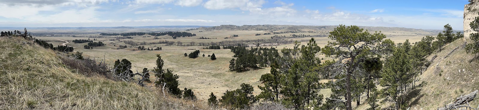
We hiked the Saddle Rock trail from the Visitor Center to the top of the bluff, which is listed as being 1.67 miles each way with 435 feet of elevation gain. Along the trail are a number of self-guided cell phone tour markers, where you can dial a number to get audio snippets to augment the interpretive signs in other parts. Saddle Rock is the little set of bumps on the far right of the bluff seen here from near the start of the trail.

Looking back towards the Visitor Center you can see Dome Rock, Crown Rock, Sentinel Rock, and Eagle Rock.

Walking through the flat lands we had our first encounter with what we call "confused crickets" - insects that chirp constantly in broad daylight; they apparently are quite common in this part of the country as we'd hear them quite often in the coming weeks. As the path started to slope upward and we rounded the corner, we could just make out the tunnel half-way up the bluff that we would be passing through - although at the time it looked more like a cave than a tunnel.

Above the mouth of the tunnel is a white band of ash, deposited by ancient volcanic eruptions in Nevada. The tunnel itself was dug by hand, because the sandstone and siltstone that the bluff is comprised of is too soft and fragile for blasting.


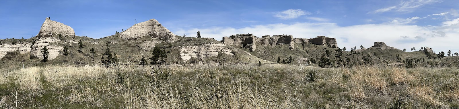
We eventually saw what appeared to be monolithic rock in the distance...

...but it ended up being the narrow edge of Saddle Rock.


Below is an example of what are called "limestone concretions". The flat rocks sticking out from the wall are limestone, and are extremely hard and solid compared to the sandstone between them which can literally be rubbed off by hand. Those limestone concretions are what are helping to hold the bluff together, by protecting the softer layers of rock underneath.

At the top, we took in the views from the two overlooks. From the North Overlook we had great views of the North Platte River and the badlands. We thought there something vaguely ironic about the fact that a golf course had been constructed right up against the badlands, but we couldn't quite put our finger on it.

The South Overlook provided views of Mitchell Pass and the rocks around the Visitor Center.

The view from the tunnel on the way back down.

At the Visitor Center, we bought some postcards to send to our moms for Mother's Day. They said at the desk that we could leave them there and they'd send them out, so we wrote them in the T42 and dropped them at the desk on our way out. We guess we should have clarified how they were sending them, because the cards ended up taking over two weeks (arriving well after Mother's Day) to make it California; we're guessing they went out on these things:

-----
Our next stop for the day was about 50 miles north: the Agate Fossil Beds National Monument. Here, fossils from the Miocene Epoch (20 million years ago) were discovered by a rancher in the late 1800's, and many more were found during archeological digs in the early 1900's. We started our visit with the Visitor Center displays, which included not only various fossil displays...


Our accommodations that night were in the city of Harrison, in the "Harrison City RV Park" - basically a couple of parking spaces on the street by the park, which had electric (which we didn't use) and water (which was off when we arrived) hookups. The nearby restrooms were marked "Closed for the Season", but shortly after we arrived a couple came by and said they had seen us pull in and would open the restrooms and turn the water on for us. Very friendly folks!


To be honest, we weren't sure exactly where the Mexican Canyon Trail led. The park has a ridiculous set of maps in their guide which show the trails from different quadrants of the park, sometimes larger, sometimes smaller, but always with the same amount of information - or lack thereof. A number of side trails are unnamed, and there are no landmarks to orient you. We hoped that the trail would lead to the bluffs seen in the distance here.


This was pretty much the end of our Nebraska adventures. The next day, we'd be crossing over into South Dakota...

Comments
Post a Comment